


In 2018 Batho, Bloemfontein’s oldest existing historically-black township or so-called ‘location’, celebrates its centenary. Compared to other South African townships of similar size and age, Batho is no ordinary township because of its rich and colourful history. During the past 100 years much had happened there, most notably on a socio-political level. For example, consider the fact that the well-known founder-member and first speaker of the South African Native National Congress (later ANC), Thomas Mapikela, lived in Batho until his death in 1945. Other truths about Batho are more obscure and not widely known, such as the fact that at the time of its founding, Batho was considered a so-called ‘model location’ which served as an example of how an ideal urban location was to be laid out and administered. During the past century Batho experienced both good and bad times, including its ‘Golden Age’ of the 1920s and 1930s, the economic downturn which followed the Second World War (1939–1945), and in recent years, the regeneration and renewal triggered by Operation Hlasela, a township renewal project launched by the Free State Provincial Government.
Batho and its founding history cannot be viewed in isolation from that of Bloemfontein’s first and oldest main location, namely Waaihoek (see old map) and, to an extent, the other smaller old locations, namely Kaffirfontein, Cape Stands, and the No. 3 Location. The strong historical link which existed between Batho and the mentioned locations derives from the fact that Batho’s original residents all hailed from Waaihoek, Kaffirfontein, Cape Stands and the No. 3 Location. Why and when did these people settle in Batho? The annual report of Bloemfontein’s mayor for the year 1897 reported that Bloemfontein’s city council (hereafter also council) faced a dilemma: all available plots in Waaihoek had been occupied with virtually no space left for expansion.
According to the then vice-mayor, Mr C.G. Fichardt, the council reached the point where it had to decide whether Waaihoek, being so near the town, was not already large enough. Either newcomers were to be provided with plots in Kaffirfontein, which was far away from town or, in the words of Fichardt, they had to be accommodated in “a third location somewhat nearer”. In practical terms, this ‘third location somewhat nearer’ meant a new location situated closer to town than Kaffirfontein but not as near the town as Waaihoek.
The fact that Batho was only established in 1918 meant that the council’s decision to lay out a new location and demolish Waaihoek was not taken overnight. A number of factors, some of which had been in the making for some time while others were more recent at that time, contributed to the council’s decision. Although the crowded conditions in Waaihoek were an important driving force in the municipality’s quest to develop a new location, there were also other factors. These included worsening race relations in Bloemfontein and, most notably, the white residents’ growing prejudice towards people of colour and Waaihoek’s close proximity to the white ‘Town’ or, as Mayor L.W. Deane put it, “the position of the location in relation to the European portion of the city”. Other contributing factors were the growing urbanisation of rural black and coloured people which caused large numbers of them to migrate to Bloemfontein, and the Spanish Influenza epidemic of October 1918, which was aggravated by the slum conditions and overcrowding in Waaihoek.
During the course of 1918, the council officially decided that a new location had to be developed east of the Johannesburg-Cape Town railway line. In the mayor’s annual report for 1919–1920, it was reported that according to the “universally accepted principle of segregation”, the council decided that “the South-Eastern quarter of the town, bounded roughly by the Natal [railway] Line and the Cape [railway] Line shall be the area where a hygienic Native township shall be developed with a higher standard of housing than that usually associated with the locations.”
Mayor D.A. Thomson’s statement is probably the first official mentioning in municipal records of Batho’s imminent founding. Since then the council initiated a resettlement process which “moved all the Africans across the railway”, to quote Councillor A.G. Barlow (see recent map). It seems that most of Waaihoek’s residents were eager to move to Batho, because in May 1919 Barlow reported in a council meeting that Waaihoek “was slowly vanishing at present, and people were going over to the big location on their own account”.
Bloemfontein’s city council was adamant that Batho became the Union of South Africa’s first ‘model location’. In practical terms, this meant that Batho’s general layout, the size of individual plots, the quality of the houses and the general administration of the location adhered to the “best town-planning lines”. For example, to ensure that Batho’s houses complied with building regulations, a unique housing scheme known as the ‘Bloemfontein System’ was implemented. In terms of this scheme, residents were allowed to build their own houses with the municipality’s financial assistance. Building material was provided on “easy purchase terms” by means of a municipal loan. Batho’s houses were, evidently, of a much better quality than those of Waaihoek and displayed a pleasing variety in terms of architecture and design, varying from four-room ‘cottages’ to five- and six-room ‘homes’, including verandah houses and stoep-room houses.
Furthermore, the houses were built on plots that measured 50 x 70 feet, whereas Waaihoek’s plots measured 50 x 50 feet. Importantly, the municipality encouraged individual home-ownership despite the contradiction embedded in this benefit due to the fact that the Union’s black people were not allowed land ownership outside the then tribal reserves. In terms of the general administration of Batho, it must be emphasised that the local council led the way nationally with the implementation of its Location Regulations in 1924 which, among others, made provision for a Native Advisory Board. This board offered Batho’s plotholders an opportunity to have a say in the management of their own affairs.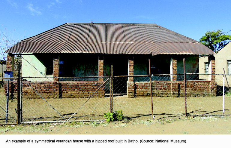
The combination of home-ownership, financial assistance and quality houses built on sizeable plots that were big enough to lay out gardens became Batho’s winning recipe. As a result, Batho became the national blueprint for location layout and set a worthy example for other towns and cities in the Union as far as location administration was concerned. Indeed, Batho became a ‘model location’ in the eyes of many municipal officials who, in those days, happened to be mostly white. Importantly, it seems that Batho’s residents themselves also agreed with the notion of Batho as a ‘model location’. A Batho resident named ‘Askari’ described Batho as “the best in South Africa” while another, Mr B.M. Mlamleli, boasted that Batho “set an example which the Government even had to copy”.
References
Barlow, A.G. 1952. Almost in confidence. Cape Town: Juta & Co.
Cooper, J.R. “The Municipality of Bloemfontein: native housing and accommodation”, South African Architectural Record 28(6), June 1943, pp. 120–123.
Free State Provincial Archives: MBL 1/2/4/1/6, Location Regulations 1924; MBL 3/1/5, Mayor’s minute 1897; MBL 3/1/7, Public Health Report for 1902, Bloemfontein, O.R.C.; MBL 3/1/19, Mayor’s minute 1919–1920; MBL 3/1/19, Mayor’s minute 1923–1924; MBL 3/1/19, Mayor’s minute 1926–1927.
Schoeman, K. 1980. Bloemfontein: die ontstaan van ’n stad, 1846–1946. Cape Town: Human & Rousseau.
The Friend, 22.1.1918, p. 4; 9.1.1919, p. 8; 6.1.1919, p. 4; 13.1.1919, p. 8; 13.5.1919, p. 8; 2.8.1921, p. 4; 14.12.1927, p. 13.




Comments are closed.